March 14, 2021
Some Suggestions for Cycling in Liverpool
td; dr. If you just want my suggestions for how we can make cycling better, skim through for the bits broken out like this.
I do lots of cycling, as anyone bored by my continual #InTheSaddle posts on Instagram will attest. It's how I get to work and back; how I visit friends outside the city centre (and in neighbouring towns and villages); and how I get exercise.
It's been a gradual thing—I didn't have a bike at all at university, or for most of the time I lived in Bury St. Edmunds. I bought my first mountain bike just before I moved to Cambridge, and understandably started using it lots more there. When I moved to Italy, both bike and car went too, and since moving to Liverpool in 2008 my bike usage has continued to rise and now, despite a penchant for fast cars, I can't remember when I last drove a car—it must be getting on for a decade.
When the first lockdown started, I switched my exercise rides away from my well-worn options of the prom along the river, through Sefton and Prince's Parks, and the canal and loop line. I was looking for less populated routes, to stay safer from the virus, and leave a tiny bit more room for others to get outside too.
That resulted in me unlocking (more of) North and East Liverpool, opening up lots more of the city and joining up other sections that I knew well but hadn't worked out how close they were to each other. I've also been pondering, off and on as I cycle around, about how we can make the city better for other people to cycle in too.
Coincidentally, Liverpool City Council have a consultation on more cycling improvements running right now. Go and fill it in if you're local. I'm going to send them this blog post too, as some related-but-different options.
It was great to see how quickly the council rolled out its network of new, segregated cycle lanes. I've used the Stanley Road and West Derby Road ones regularly.
The real revelation for me though was finding that the existing cycle network is actually pretty good. It's just quite hidden. Despite being a frequent cyclist, the obvious routes around the city are those used by cars. For those just switching from driving that will be even more likely. Helping them find better routes will make their cycling more likely to stick.
In my experiments into 15-minute cities I've been looking more at the cycling-focused views of OpenStreetMap, and so ended up looking at that to find new routes to explore.
Who knew there are two cycle routes (not including the Loop Line!) that run broadly parallel to Queens Drive? Not me. Cycle Route M will get you all the way from Walton to Old Swan on quiet and residential roads. Cycle Route O tracks similarly parallel on the far (from the city-centre) side of Queens Drive from almost Fazakerley to Broad Green—it's not as quiet, running along Long Lane, and gets a bit tight through West Derby village as Town Row isn't very wide, but I've been cycling it lots since discovering they existed.
Use and promote one of the cycling-focused OpenStreetMap maps. Use OpenCycleMap.org or the CycleOSM layer of OpenStreetMap in maps shared by the cycling team. Contribute fixes or additional data to OpenStreetMap, which is used to make both of those maps. I'm happy to show people how to do that.
I've also been using Cycle Route 7 from Broad Green through Wavertree Technology Park and Edge Hill back into town, ever since I found it after delivering visors to Broad Green Hospital.
That's a great alternative to Edge Lane, particularly at the Broad Green end where it runs along quiet residential roads. That's pretty well signposted at the key points, like this crossroads pictured below:

However, as that shows, the signs aren't always the biggest, and they often lose the cycle route number or letter in favour of the name of the area they're immediately headed for. I don't think we should lose the area names, but the route letter/number is important. Otherwise it's hard to know if a sign turning off from the road you're on is for the continuation of the route you're following or where another route crosses it.
Only having the signs at key points where the route changes also means that if you miss one, it's hard to know if you're still following the route correctly. That's particularly problematic where the route runs through residential areas, because you're often not following roads where it's obvious how the route progresses.
Stick route name/number stickers on lampposts at regular intervals on routes. Getting a load of stickers printed up with the same up-arrow, bike logo and route identifier in the photo above (probably with them arranged top-bottom rather than left-right?) shouldn't be too expensive. Then stick them on lampposts at reasonable intervals all along the route so that cyclists can check they've not missed a turning, and won't have travelled too far if they do stray from the route and stop seeing signs. It will have the added bonus of making the cycle network more visible to everyone.
Moving on to something a bit more involved, we could make it easier for people to plan their routes using bikes. CycleStreets and cycle.travel are pretty good options for routes that are solely by bike, and give options for quieter routes rather then just the fastest.
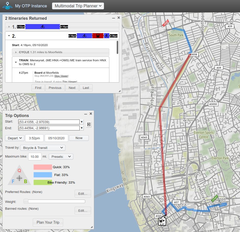
While I'm happy cycling five or six miles to get somewhere, not everyone is. One option for those sort of distances (and one I use plenty when travelling further myself) is sticking the bike onto the train for some of the route. OpenTripPlanner will do that sort of multi-modal trip planning, and is reasonably easy to get up and running. Here's an example route I plotted from DoES Liverpool up to South Park in Bootle:
Create a Liverpool version of the open-source multi-modal route planning app Trufi. The Trufi app is very similar to the CityMapper app, but you don't have to wait for them to decide that they should add Liverpool. It lets people plan routes that use both bikes and the train; or walking, bus and train; or waking, bus and CityBike; or...It's probably best for the Council to build, but could also be a standalone thing. There'd be some initial up-front development work, and then a smaller ongoing commitment to keep the data sources (it'll need an update to timetable information when the trains change that, for example) up-to-date, etc. Again, I'd be happy to help out, at any level from a bit of advice through to building it...
Beyond the infrastructure of cycle lanes, and signage, and better apps, are there other things likely to hamper people's move to cycling for their travel?
Looking at this chart from the Cycling and Walking: A Faster Route to a Safer and Stronger Liverpool City Region policy briefing from the Heseltine Institute, it looks like the less affluent areas of the city are slightly less likely to cycle and more likely to use the bus.

There's nothing wrong with that, and my multi-modal trip planner app recommendation would help bus users too, but if they're worried about using the buses due to coronavirus it would be good to tempt them onto bikes rather than into cars.
Set up schemes to let people buy the kit they need to start cycling. This is definitely the wooliest of my recommendations, but maybe one of the more important. Could the Council set up some grants to let those who can't afford it buy a bike? And/or the additional bits-and-pieces that make sense: lock, lights, helmet, panniers, waterproofs...? Or work with a credit union to offer a get-biking loan, paid back at the same sort of rate as a weekly bus pass?
I look forward to seeing what comes of the latest consultation, and it'd be great to add some of these ideas too.
Posted by Adrian at March 14, 2021 07:41 PM | TrackBackThis blog post is on the personal blog of Adrian McEwen. If you want to explore the site a bit further, it might be worth having a look at the most recent entries or look through the archives or categories over on the left.
If you want to hire my company to help you with the Internet of Things then get in touch. If you want to learn more about the Internet of Things, then buy my book Designing the Internet of Things (amazon.co.uk amazon.com).